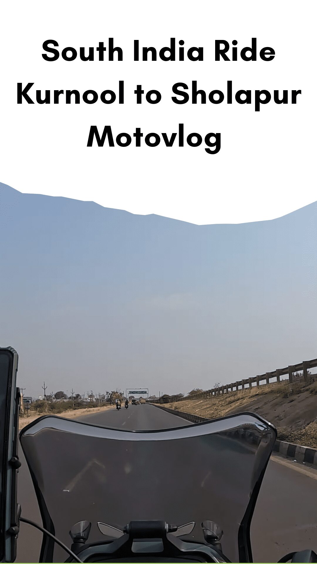
South India Ride Kurnool to Sholapur Motovlog
South India Ride Kurnool to Sholapur on Dominar 400 UG Motovlog [S1 – Ep15]
India’s Andhra Pradesh state includes the city of Kurnool. It was the Andhra State’s capital (1953–1956). The city’s name is frequently used, “The Gateway to Rayalaseema.” The City of Gem Stones is another nickname for Kurnool. Additionally, it acts as the Kurnool district’s administrative center. It’s the fifth most populated city in the state with 484,327 residents. The Tungabhadra River situates it. Even though the region has been inhabited for thousands of years, the Konda Reddy Fort’s building in the 16th century CE marked the establishment of the contemporary Kurnool.
History
Paleolithic era
The Paleolithic-era rock paintings in Ketavaram are (18 kilometers from Kurnool). Additionally, there is significant rock art and paintings nearby in the Jurreru Valley, Katavani Kunta, and Yaganti in the Kurnool District, which may date from 35,000 to 40,000 years ago.
The district’s Belum Caves are significant both geologically and historically. There are hints that these caves were once home to Jain and Buddhist monks. Inside the caves, numerous Buddhist relics were discovered. The pre-Buddhist era artifacts discovered by the Archaeological Survey of India (ASI) date the vessel fragments recovered in the caverns to 4500 BC. These artifacts are currently kept in the museum in Ananthapur.
The Vijayanagara Era
Before the 11th century, only little was known about the town of Kurnool. This settlement was documented as early as the eleventh century. It has grown as a transit hub along the southern banks of the Tungabhadra River.
The Kurnool Fort was built in the sixteenth century by King Achyuta Raya, Sri Krishnadeva Raya’s successor. 12th-century Chola rule was followed in the 13th century by the Kakatiya dynasty. After some time, it was ruled by a jaghirdar before joining the Vijayanagar kingdom. Surrounded by the Tungabhadra River’s southern banks, Kurnool evolved into a transit hub.
Mughal Empire
In the 17th century, the Abyssinian Abdul Wahab Khan overthrew King Gopal Raja of the Kingdom of Vijayanagar and ruled the region for 16 years until his death.
Kurnool was influenced by the Mughals, led by Emperor Aurangzeb, in 1686. Kurnool’s latter history saw the Nawabs in charge until the British Empire took control in 1839.
Nawabs
The last Nawab of Kurnool, Andhra Pradesh, was Ghulam Rasul Khan Bahadur (July 12, 1840–1840). Up until the East India Company’s conquest of the kingdom in 1839, he governed from 1823 to 1839. A fight between the British Indian Army and the monarchy began on October 12, 1839, and lasted six days before the king was imprisoned on October 18. Later, he was sent to Tiruchirappalli Central Prison, where he passed away on July 12, 1840.
Following Independence
Kurnool was the former Andhra State’s capital from October 1, 1953, to October 31, 1956. On November 1, 1956, the state was combined with the Telugu-speaking areas of Hyderabad State to become Andhra Pradesh, with Hyderabad serving as the capital. Kurnool is currently located in the partitioned state of Andhra Pradesh.
Geography
The coordinates of Kurnool are 15.8333°N 78.05°E. Its typical elevation is 273 meters (898 feet). On the banks of the Tungabhadra River is the city of Kurnool. Additionally, the rivers Hundri and Neeva pass through the city. The Dutch constructed the K.C.Canal (Kurnool-Cuddapah) for irrigation before using it for transportation.
Cityscape
Konda Reddy Fort is one of the city’s landmarks. Kurnool’s historical monument and foremost tourist attraction is situated in the city’s northeast and was formerly known as Kondareddy Burj. The sculpture garden and ancient cave known as Orvakal Rock Gardens are on the city’s southeast side.
Climate
Kurnool has hot savanna weather (Köppen BSh), with summertime highs of 26 °C (78.8 °F) to 46 °C (114.8 °F) and wintertime lows of 12 °C (53.6 °F) to 31 °C (87.8 °F). About 920 millimeters of rainfall on average each year (36 in).
Kurnool Tourism
The Rayalaseema Gateway
Kurnool, a small town in Andhra Pradesh, is a site with a lot of historical significance and lovely surroundings. A lot of history has left its mark there. The Gateway of Rayalaseema is another name for the city.
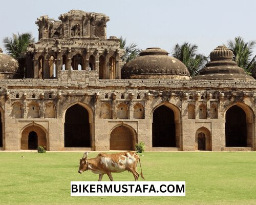
The final Hindu king Gopal Raju’s palace is still standing in Kurnool, along with the summer palace that the Kurnool kings built in the 16th century and the remains of a Vijaynagar Empire fort with ancient Persian and Arabic inscriptions.
Kurnool is derived from the names Kandanavlu or Kandanlu, which were the names of a former crossing point across the Tungabadra River where it was thought that the caravans oiled their tires. The Belum Caves and the Paleolithic rock art near Ketavaram have historical significance in the city.
Yaganti
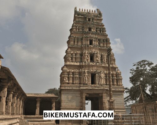
The Sri Yagantiswamy temple, devoted to Lord Shiva and the ideal place to experience Andhra Pradesh tourism, is in Yaganti, a well-known tourist destination in the Kurnool region of Andhra Pradesh, India. The ancient Sri Yagantiswamy temple, also called Uma Maheshwara Temple, was built between the fifth and sixth centuries.
The temple contains the Ardhanareeswara idol, a combined version of Shiva and Parvathi. This fantastic statue of the gods is exquisite to look at and was carved from a single piece of stone. The temple puts on a grand celebration for the Maha Shiv Ratri festival, which happens around October or November each year. During this time, a large number of visitors to the temple, particularly followers of Lord Shiva, arrive.
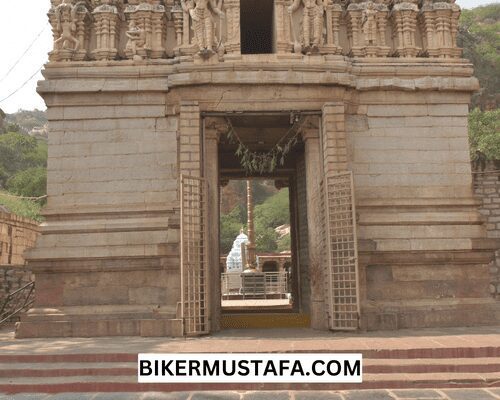
In addition to its religious significance, the majestic temple is held in high regard for its numerous eye-catching and peculiar features. To begin with, Yaganti is maybe the only temple in which Lord Shiva is worshipped as an idol rather than as a Shiva Linga. The Agastya Pushkarni, where water flows year-round from the base of the hill, is another feature of the shrine. As a form of adoration to the deity, worshippers bathe in the holy water.
Background of Yaganti
The simple beginnings of the temple are the subject of numerous myths. One story claims that the sage Agastya intended to erect a temple for Lord Venkateswara here. The sage performed penance for Lord Shiva after realizing that the statue of the Lord could not be placed here for some reason. The sage realized the location suited him better when Lord Shiva emerged. Then he asked the Lord to take the Ardhanareeswara form, the one worshipped here today, and the Lord complied.
Per a second legend, the Lord manifested as a tiger while being worshipped by a devotee of Lord Shiva by the name of Chitteppa. Chitteppa screamed, “Neganti Shivanu ne Kanti,” which translates to “I saw Shiva I saw,” after realizing it was Lord Shiva in the tiger form.
Many saints have lived in the numerous natural caves in the hills surrounding the temple throughout the millennia, including the Great Telugu saint and astrologer Potuluri Veera Brahmam Garu.
Caves in Yaganti
Around Yaganti’s main temple, there are a lot of cave temples. These caves scarcely receive any natural light, but the countless diyas that have been lighted within give forth artificial light that gives the caves a vibrant appearance.
The Veera Brahmam Cave is where Potuluri Veera Brahmam, renowned as India’s Nostradamus, wrote some of the chapters of his prophecies. Saint Agastya is thought to have undergone penance there to obtain Lord Shiva’s blessings. The Kala Gnanam and the Venkateswara Cave are other notable caves. From dusk to dawn, these caves are all accessible for worship.
Customs and Culture
The temple represents the diverse traditions and cultures that make up a vibrant and colorful country. Despite being surrounded by a forest, the temple is always silent throughout the day. It is constantly bustling with tourists and pilgrims doing daily business, preparing for plays based on different myths, or enjoying the many festivals. The communities close to Yaganti continue to be vibrant and festive throughout the year, as they have undoubtedly been for decades.
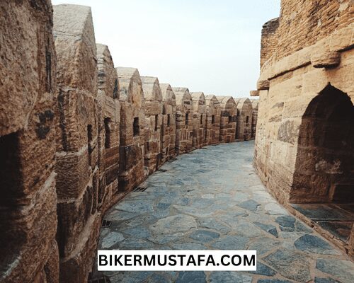
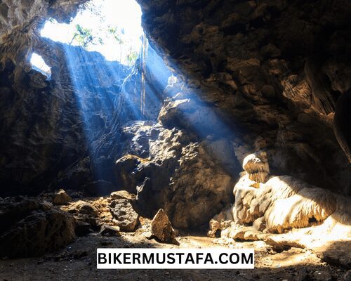
Kurnool’s Belum Caves
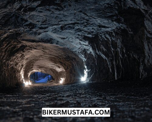
The largest and longest cave system in India that is still accessible to tourists is called Belum Caves, and it is situated in the Kurnool district of Andhra Pradesh. The caverns, which are the second-largest in India after the Krem Liat Prah in Meghalaya, are renowned for their unusual structures like stalactite and stalagmite formations. Limestone was created as a result of the millions of years it took for the caves to form.
The Belum Caves, one of the strategically protected monuments of national significance, features several trails with beautiful patterns of water streams on limestone that are sure to leave you wondering about the beauty and strength of nature. More than three and a half kilometers of the cave have been successfully explored as of this date. However, only one and a half kilometers are open to regular travelers.
The Pataalaganga point, where the Belum Caves’ depth reaches as far as 46 meters, is one of these locations. A year-round underground stream flows at this place, sliding over the rocks before resuming its underground course. The cave features numerous lengthy passages, galleries, sizable freshwater cavities, and water tunnels. Three magnificent sinkholes can be found. The three stunning sinkholes created by the movement of underground water flow make the caves an amazing feast for geologists. To honor the duties played by monks in the caves, a massive statue of Lord Buddha measuring 40 feet high was erected outside the caverns.
The Belum Caves’ past
The ancient vessels and their remains, dated to 4,500 BC, were discovered. These caves developed over millions of years due to the constant deposition of limestone beneath the earth’s surface. In the beginning, it was thought that cave dwellers lived there. However, Jain and Buddhist monks also moved in, using the caves for meditation.
Locals have always been aware of the caves, but British geologist and archaeologist Robert Bruce Foote made the discovery in 1884. However, the caves went undiscovered until a German exploration team led by Herbert Daniel Gebauer saw them in 1982. The site was designated as protected by the state government in 1988. It was opened to the public in 2002, and it quickly rose to the top of Andhra Pradesh’s list of coveted tourism assets. Along with Buddhist artifacts, the site also contained many mud containers used by Jain saints, according to the archaeological agency.
Belum Caves’ interior structures
The black limestone caves known as Belum Caves include some of the most bizarre cave structures. There is an entry room and a maze of 16 routes inside the caves. The magnificent rock formations known as Saptasvarala Guha are among the cave’s most outstanding characteristics (the chamber of seven notes). Here, you may hear the melodious sound produced when wood, bamboo, or your knuckles are struck. Simhadwaram, which translates to “doorway for gods,” is a stunning archway that appears to have a lion’s head on it.
Numerous lingams created naturally can be found inside the Kotilingalu Chamber. Stalactites are used to create the lingams. Another stalactite structure that resembles a banyan tree is Voodalamari. The hood of thousands of cobras is the shape of Thousand Hoods, another stalactite formation. Dhyan Mandir is an intriguing rock structure made of limestone that resembles a bed with a pillow; according to local folklore, all saints selected this location as their primary site of meditation.
The caves contain remnants of the Jain and Buddhist cultures. The Jain and Buddhist monks who entered the caves are commemorated in part of the caves’ architecture. In the cave, relics were found, including a saint’s bed and a meditation nook—a few of the artifacts discovered inside the caves date around 4500 BC.
Kurnool’s Rollapadu Wildlife Sanctuary
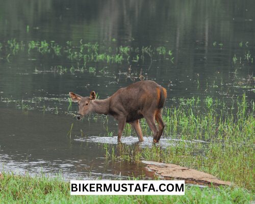
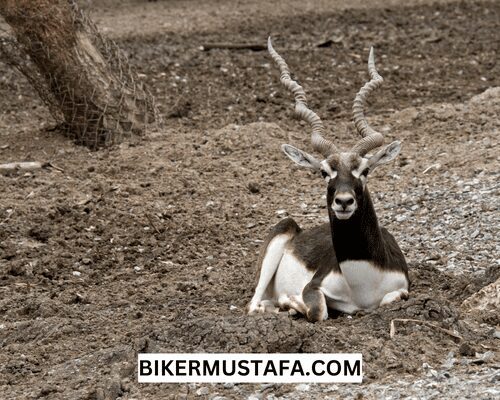
Rollapadu, a wildlife sanctuary covering 614 square kilometers in the Kurnool district of Andhra Pradesh, provides tourists with a chance to experience the wild, get close to nature, and see a variety of unique flora and fauna. Rollapadu, founded in 1988, is particularly well-known for housing the lesser florican and great Indian bustard endangered species. Many birds and reptiles call the vast, spread-out wildlife sanctuary home.
Numerous birds and reptiles live in the wildlife sanctuary spread out over a vast region. Blackbucks, sparrows, bonnets, mynas, Indian rollers, Russell’s vipers, and Indian cobras are just a few examples. Here, a variety of endangered species can be seen.
A day spent in Rollapadu might be worthwhile if you’re a nature lover passionate about getting close to and learning about biodiversity. The Rollapadu Wildlife Sanctuary also serves as a fine example of how people and the environment can coexist thanks to the surrounding Rollapadu hamlet, an artificial water reservoir conserved for the consumption of wildlife, and another reservoir for collecting rainfall.
The Ideal Season To Visit Rollapadu Wildlife Sanctuary
The best time to visit Rollapadu Wildlife Sanctuary is winter, specifically between November and February. Temperatures in Kurnool range from 25° to 26°. In the coldest months (December and January), the minimum temperature drops to 17oC, and the high temperature hovers around 30oC.
From June through September each year, Kurnool receives about 660 mm of precipitation. Tourists can avoid the season if they choose. Still, if the rains are too alluring, they can visit the sanctuary towards the end of the monsoon season, which is in September and October, when the forest is lush and green, and the atmosphere is charming. The sanctuary is consistently between 32°C and 23°C in temperature throughout the year.
Because the mercury typically reaches 39oC during the summer peak months, summer is not advised. However, those who want to take a safari trip in the Rollapadu Wildlife Sanctuary might find some relief in the mornings and evenings. During this time of year, the typical daily temperature is about 32 °C.
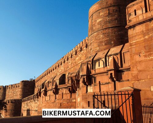
Kurnool’s Konda Reddy Fort or Kondareddy Buruju
The most critical site in Kurnool is Konda Reddy Fort, also known as Kurnool Fort or Kondareddy Buruju, which is about 2 kilometers from the railway station. Although the fort has suffered dramatically from ruins, it remains one of the town’s top attractions and has long served as a marker for Kurnool. The kings of the Vijayanagar Empire built the building. The humble-looking structure previously held a tunnel that ran beneath the Tungabhadra River and now has a spectacular watch tower that overlooks the city built around it.
People Also Ask:
Which language is spoken in Kurnool?
Kurnool is a Telugu-speaking region.
Is there Kurnool in Hyderabad?
A road trip of 212 KM separates Kurnool and Hyderabad. An airstrip of 180 KM separates Kurnool and Hyderabad.
Is Kurnool a metro city?
Kurnool’s metro region had 686,000 residents in 2021, up 3.16% from the previous year. Kurnool’s metro region had 665,000 inhabitants in 2020, up 3.26% from 2019.
Why is Kurnool famous?
The Indian town of Kurnool is well-known for its impressive caves and temples and its role as a historical center. Although the Belum caves will always hold a particular place in my heart, this town also has some fantastic historical sites worth visiting.
Recommended Articles:
South India Ride Hubli to Bangaluru Motovlog
Solo Riding Ahmednagar to Pune Motovlog
Solo Riding Dongaon to Ahmednagar Motovlog
South India Ride Kanyakumari to Rameswaram on Dominar 400 UG Motovlog