South India Ride Rameshwaram to Pondicherry Motovlog
South India Ride Rameshwaram to Pondicherry on Dominar 400 UG Motovlog [S1 – Ep13]
A municipality in the Ramanathapuram district in the Indian state of Tamil Nadu, Rameswaram is also known by the transliterations Ramesvaram and Rameshwaram. It is located on Pamban Island, 40 kilometres from Mannar Island in Sri Lanka and divided from the mainland by the Pamban canal. At the southernmost point of the Indian peninsula, it is in the Gulf of Mannar. The Pamban Bridge connects Rameswaram Island, popularly known as Pamban Island, to the rest of India. The railway line between Madurai and Chennai ends in Rameswaram. It is regarded by Hindus as one of the holiest locations in India, along with Varanasi, and is a stop on the Char Dham pilgrimage.
Ancient Hindu traditions claim that Lord Ram constructed a bridge from this location to Lanka to save his wife Sita from Ravana, who had kidnapped her. The Hindu deity Shiva is the subject of the town’s central temple, which has a solid connection to both Rama and Shiva. For Shaivas and Vaishnavas, the temple and the town are sacred pilgrimage destinations.
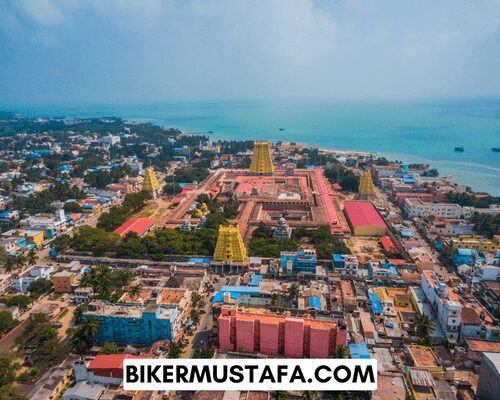
Geological evidence indicates that the Rama Sethu was once a land link between India and Sri Lanka, and Rameswaram is the second-closest location to access Sri Lanka from India. The Sethusamudram Shipping Canal Project, Kachchatheevu, Sri Lankan Tamil refugees, and the arrest of a local fisherman for alleged cross-border actions by Sri Lankan Forces have all made headlines about the town. The municipality that oversees Rameswaram was founded in 1994. The town has a population of 44,856 and a 53 km2 (20 sq mi) land area as of 2011. In Rameswaram, the bulk of workers is employed in tourism and fishing.
Legend
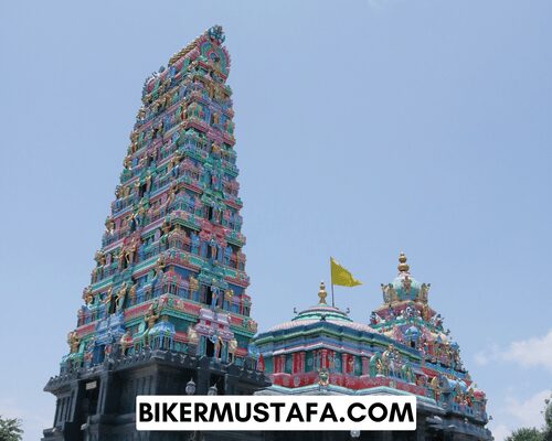
In English, Rameswaram is a Sanskrit epithet of Shiva, the principal deity of the Ramanathaswamy Temple. According to the Hindu epic Ramayana, Rama, the seventh manifestation of the god Vishnu, pleaded to Shiva here for forgiveness for whatever transgressions he may have made while fighting the evil king Ravana in Sri Lanka. According to the Puranas (Hindu scriptures), Rama, his wife Sita, and his brother Lakshmana installed and worshipped the lingam (a famous symbol of Shiva) here on the advice of the sages to atone for the sin that Brahmahatya committed by slaying the Brahmin Ravana.
Rama needed a lingam to worship Shiva and asked his dependable lieutenant, Hanuman, an incarnation of Shiva, to bring one from the Himalayas. Sita constructed a replica of the lingam in the temple’s sanctum out of sand from the local shoreline because it took longer to transport the original. The original Ramayana, written in yudha Kanda and by Valmiki, provides strong support for this story. The Ramsetu bridge, which proceeded to Dhanushkodi in Rameswaram and Talaimannar in Sri Lanka, is thought to have been constructed by Rama at Sethu Karai, a location 22 kilometres before the island of Rameswaram. Another account, cited in the Adhyatma Ramayana, states that Rama installed the lingam before building the Bridge to Lanka.
History
Tevaram, the Tamil works on Shiva written in the seventh and eighth centuries by the three crucial Saiva Nayanars (Nayanars), Appar, Sundarar, and Thirugnanasambandar. The Ramanathaswamy Temple and the island’s use as a stopover for travellers heading to Sri Lanka (historically known as Ceylon) are central to Rameswaram’s history. Rajendra Chola I, the Chola ruler (1012–1040 CE), ruled over the town briefly. The Jaffna kingdom maintained close ties to the island (1215–1624 CE), which also claimed the title Setukavalan, which means “custodians of the Rameswaram.” Their official religion was Hinduism, and they gave generously to the temple. Setu was employed as a dynasty marker on their coins and inscriptions.
Firishta claims that despite fierce opposition from the Pandyan princes in the early 14th century, Malik Kafur, the chief general of Alauddin Khalji, the ruler of the Delhi Sultanate, entered Rameswaram during his political campaign. He built a mosque named Alia al-Din Khaldji to celebrate Islam’s triumph. The Pandya dynasty ruled over the modern-day Ramanathapuram, Kamuthi, and Rameswaram during the beginning of the 15th century. The town was governed by the Vijayanagara Empire beginning in 1520 CE.
The Madurai Nayak splinter group, known as the Sethupathis, ruled Ramanathapuram and donated to the Ramanathaswamy temple. The efforts of Muthu Kumara Ragunatha and Muthu Ramalinga Sethupathi, who turned the temple into an architectural ensemble, are the most remarkable. Then, in the middle of the 18th century, the territory came under the control of several rulers, including Chanda Sahib (1740-1754 CE), Arcot Nawab, and Muhammad Yusuf Khan (1725-1764 CE). Rameswaram was directly governed by the British East India Company and acquired by the Madras Presidency in 1795 CE. The town joined Independent India after 1947.

Geography
Rameswaram is 10 m above sea level on average (33 ft). The island is shaped like a conch and covers a surface area of 61.8 km2 (23.9 sq mi) due to the presence of the sea. Of the numerous islands surrounding it, including the Palk Strait in the northwest and the Gulf of Mannar in the southeast, 74% of the territory has sandy soil. The Ramanathaswamy Temple occupies a sizable portion of Rameswaram.
Virtually no waves characterise Rameswaram’s beach; the sea waves only reach a height of 3 cm (0.10 ft), and the scene resembles a vast river. Rameswaram experiences a dry tropical climate with low humidity. The city receives an average of 75.73 millimetres (2.981 in) of monthly rainfall, most of which comes during the North-East monsoon from October to January. At Pamban station, the highest temperature recorded was 37 °C, and the lowest was 17 °C.
Off Sri Lanka’s northwest coast, between Rameswaram and Mannar Island, there is a group of limestone shoals known as Ramsetu Bridge. According to geological data, this Bridge may have once been a land link between India and Sri Lanka. The Bridge, which connects the Palk Strait to the Gulf of Mannar in the northeast, is 29 kilometres (18 miles) long (South-West). According to legend, until storms deepened the waterway in the 15th century, it was accessible on foot. According to temple records, Rama’s Bridge was above sea level until it collapsed after a typhoon in 1480 CE.
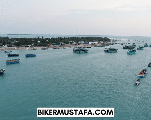
The Ramayana of Valmiki, an ancient Indian Sanskrit epic, is where the Bridge was first referenced. Rama’s Bridge, also known as Rama Setu (Sanskrit: Setu: Bridge), is the name of the Hindu mythological bridge that Rama built with the aid of his Vanara (ape men) army to reach Lanka and save his wife Sita from the demon king Ravana.
In verses 2-22-76 of the Ramayana, where the Bridge is referred to as Setubandhanam, Rama is credited with building it. Sethusamudram, which translates to “Sea of the Bridge,” is the name of the body of water that divides India and Sri Lanka. This region is identified on maps created in 1747 CE by a Dutch cartographer and kept at the Tanjore Saraswathi Mahal Library as Ramancoil, a colloquial name for the Tamil Raman Kovil (also known as Rama’s Temple). The place is referred to by numerous names, including Adam’s Bridge, Sethubandha, and Sethubandha Rameswaram, on many other maps in Schwartzberg’s historical atlas and other sources, including Marco Polo’s travelogues.
Communication and Transportation
The Pamban Bridge, a cantilever bridge across the Palk Strait, connects Rameswaram and the Indian mainland. The 2,065-meter-long (6,776-foot) railway bridge first opened to traffic in 1914. The railroad bridge’s double-leaf bascule component can be raised to allow ships to pass underneath it. The railway bridge previously supported metre-gauge trains, but Indian Railways refurbished the Bridge in a project completed on August 12, 2007, allowing it to support broad-gauge trains. In the past, labourers manually operated levers to open the Bridge’s two leaves.
About ten ships—coast guard ships, fishing boats, and oil tankers—pass under the Bridge every month. After the Bridge was finished, metre-gauge lines were built from Mandapam to Pamban Station, where they split into two directions: one heading toward Rameswaram, which was 6.25 miles (10.06 km) away, and the other, a branch line that went for 15 miles (24 km) and ended at Dhanushkodi. Between 1915 and 1964, the renowned Boat Mail travelled along this railway from Chennai Egmore to Dhanushkodi, when passengers were transported by ferry to Talaimannar in Ceylon. After it was devastated by a hurricane in 1964, the metre-gauge branch line from Pamban Junction to Dhanushkodi was abandoned.
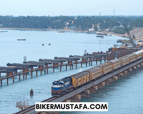
Significant cities in Tamil Nadu, like Chennai, Madurai, Trichy, and Coimbatore, are connected regularly by express trains. There are passenger and express trains that link to popular locations. The primary route from Rameswaram to the mainland is the Ramanathapuram – Rameswaram National Highway. Boats were the only transportation to Rameswaram island before a train service connected it to the mainland in 1914.
An estimated 80% of the town is covered by the 20 km of the national highway that runs through the Rameswaram municipality, which has a total road length of 52 km. The Rameswaram municipal bus terminal is home to a computerised reservation centre administered by the Tamil Nadu State Transport Corporation, which provides daily services linking Rameswaram with several cities.
The most important port in the district is Rameswaram, which offers a ferry service to Talaimannar in Sri Lanka but is only sometimes open. There is a small amount of foreign trade with Jaffna, Kaits, Talaimannar, and Colombo.
The tallest tower in India is the Rameswaram TV Tower. The tower is a 323-meter-tall circular concrete tower with a 45-meter-high square steel mast with a bottom diameter of 24 metres and a top diameter of 6.5 metres. The tower is built to withstand winds up to 160 km/h. The Pamban lighthouse and the Rameswaram lighthouse are both in Rameswaram.
People Also Ask:
Why is Rameshwaram famous for?
Sri Ramanathaswamy Temple, devoted to Lord Shiva, is one of Rameswaram’s most famous attractions, drawing thousands of pilgrims each year. This peaceful town, which is home to numerous other sacred sites, makes for the perfect spiritual gateway.
Is Sri Lanka visible from Rameshwaram?
It is located on Pamban Island, 40 kilometres from Mannar Island in Sri Lanka and divided from the mainland by the Pamban canal. At the southernmost point of the Indian peninsula, it is in the Gulf of Mannar.
What is the best time to visit Rameshwaram?
Rameshwaram is in the southernmost region of India. Hence the area experiences a tropical environment. Because of this, October through April will be the most fantastic time to visit Rameshwaram as the weather will be at its most favourable.
Is 2 days enough for Rameshwaram?
In response to your second inquiry, many people travel to Rameswaram and Dhanushkodi daily. Two days and one night are enough time for a more leisurely vacation. You stop and look at the Pamban rail bridge as you pass the road bridge before entering Rameswaram.
Rameshwaram to Kanyakumari.
The quickest and least expensive way to travel from Rameshwaram to Kanyakumari is by bus to Madurai, followed by a bus to Nagercoil and a cab to Kanyakumari. The quickest route from Rameshwaram to Kanyakumari involves a cab, which takes 3 hours and 56 minutes.
Rameshwaram Bridge.
Rameswaram island is connected to the mainland by the 100-year-old Pamban railway bridge found in Tamil Nadu, southern India. The Pamban bridge, which connects the mainland to the island over 2 km and has 143 piers, is the second-longest sea bridge in India. The beautiful magnificence of this Bridge, which is more than just a railroad overpass in Tamil Nadu, astounds visitors. This Bridge is 1 metre wide and 2.5 kilometres long, surrounded by crystal-clear blue waters as far as the eye can see. Your train ride is an experience thanks to the beauty all around you and the narrowness of this Bridge.
Rameshwaram Beach.
Pamban Beach: Pamban Beach is at the beginning of the island of Pamban and is close to the fishing port. You may enjoy a stunning view of the Pamban and Indira Gandhi Roadway Bridges from this beach. However, there are better places to swim, dive, or bathe due to the abundance of pebbles on this beach.
Kunthukal Beach-Kunthukal Beach is located in the little settlement of Kunthukal Village on Pamban Island. The distance between this beach and Rameswaram town is 12 kilometres. Fishing is the primary source of income in this area.
Amazing locations like the Vivekananda Memorial and the Marine Museum Cum Interpretation Center are close to this beach. One can also enjoy swimming, baths, and playing on the serene seashore. Service for boating and water sports has yet to begin.
Ariyaman Beach-commonly referred to as Kushi Beach, is a well-liked beach close to Rameswaram. It is situated in Ramanathapuram’s Mandapam Block’s Sattakkonvalasai Village.
This beach’s main draw is that it is a 2.5-kilometre beach that is a portion of India’s Palk Bay. This would be the ideal location to spend time with friends, family, and other loved ones during the weekend and for picnics.
Along with excellent cuisine from the booths, this location provides its visitors with a lot, including water sports activities, a children’s park, and a museum. You can travel from here to surrounding locations like Erwadi, Mandapam Beach, and a few more neighbourhood temples.
Olaikuda Beach: Rameswaram Island is unquestionably a paradise with various stunning beaches. Rameswaram’s Olaikuda is a fishing community. Olaikuda Beach, which is close to the significant Rameswaram town, is exotic.
Despite being a fishing location, the beach is relatively clean and serene, making it the ideal area to spend some time in. A coral reef surrounds this beach, while seaweed and eel grasses line the coast.
When the season is right, visitors to this beach can view Australian birds like seagulls, flamingos, and others.
Sangumal Beach: Sangumal Beach is a little beach located just next to Olaikuda Beach. Locals are well aware of this location as a fantastic spot for fishing. And visitors, particularly those from abroad, come here to enjoy the magnificent sunrise and sunset.
Even though this location is unsuitable for swimming or other activities, it has boating facilities where visitors can view the coral reefs in the Palk Strait.
Dhanuskodi Beach: Tourists to Rameswaram will never pass up the opportunity to explore this abandoned area known as Dhanuskodi, also referred to as the “Ghost town” on Rameswaram Island.
After being destroyed by a high-intensity storm in 1964, the government of Tamil Nadu proclaimed this town to be uninhabitable.
Today, Dhanuskodi is a popular destination on Pamban Island, drawing several tourists and visitors daily. It is situated near the Palk Strait. The Sri Lankan border is only 15 kilometres away from Dhanuskodi.
You can still enjoy the peace, fall of the sea, and breeze even though it is unsafe to bathe in or go swimming in the water.
Additionally, the Ramayana, an ancient Indian epic, mentions the mythological significance of this location. The Ram Setu bridge was constructed there by Lord Rama, his brother Lakshaman, God Hanuman, and an army.
All of them came back to this location after defeating Ranava and saving his wife, and Vibishana, the new king of Lanka, asked Rama to burn this Bridge. Lord Rama used his bow to break the Bridge at his request. Due to this, the location was given the name “Dhanush means Bow and Kodi means end.”
Island of Kurusadai: Kurusadai Island is a little deserted island. Diverse types of priceless coral reefs and marine species surround this island. The Gulf of Mannar Marine National Park includes this island.
Since this area is heavily protected for the importance of its marine life, civilians are typically not permitted there. Marine scientists and environment enthusiasts will enjoy exploring this island.
Even though it is off limits to the general public, visitors are welcome with the fisheries department’s approval.
Dolphins and dugongs, a type of sea cow, can occasionally be seen along the shore. Kunthukal Island’s Sea Life Museum is another location to learn more about the marine ecosystem.
Rameshwaram Temple state.
On Rameswaram island, in the Indian state of Tamil Nadu, is the Ramanathaswamy Temple (Rmantasvmi Kyil), a Hindu shrine to the god Shiva. One of the twelve Jyotirlinga temples, it is also.
Rameshwaram Temple history.
The Pandya Dynasty constructed the temple in its current form during the 12th century. Of all the Hindu temples in India, the one at this location has the longest corridor. These columned passageways range in width from 17 to 21 feet and are 25 feet tall.
Recommended Articles:
South India Ride Bangluru to Mysore Motovlog
South India Ride Hubli to Bangaluru Motovlog

2 thoughts on “South India Ride Rameshwaram to Pondicherry Motovlog”